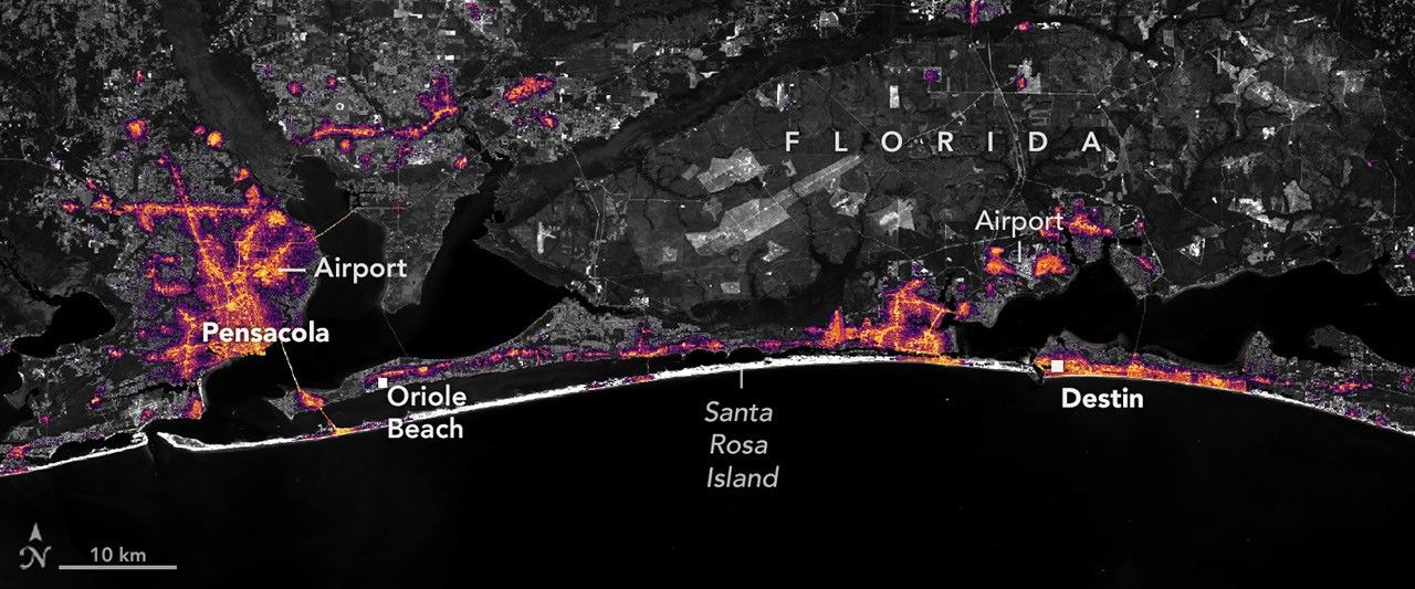
Hurricane Isaias brought flash flooding and widespread power outages along Florida’s Gulf Coast, with NASA nighttime satellite imagery mapping where lights dimmed most after landfall.
After a slow beginning to the 2026 Atlantic hurricane season, Hurricane Isaias became the year’s first hurricane on October 8 as it headed for the U.S. Gulf Coast. The storm drenched parts of the Southeast with heavy rain, triggering flash flooding in places including Alabama and Florida’s Panhandle. It also delivered strong winds that felled trees and damaged power lines—knocking out electricity for many residents.
Isaias came ashore near Destin, Florida, on the evening of October 9 as a Category 2 hurricane. At landfall, the storm’s maximum sustained winds reached 105 miles per hour (170 kilometers per hour). The National Weather Service reported that wind gusts exceeded 100 miles per hour along a swath west of the storm’s center. Early measurements included a 117-mile-per-hour gust in Oriole Beach and a 102-mile-per-hour gust recorded at Pensacola City Hall.
Those wind corridors corresponded closely with changes seen from space. High-resolution nighttime satellite imagery showed widespread dimming west of the hurricane’s eye—an indicator of power disruptions in communities hit hardest by the storm’s winds.
The observations come from NASA’s “Black Marble” nighttime lights work, including a higher-definition product known as Black Marble HD. In one comparison, researchers assembled a baseline view using a composite of nighttime lighting from August 2026 to represent typical conditions before the storm. They then compared it with imagery captured on October 11, once most storm clouds had moved out of the region.
Black Marble HD is derived from the day-night band of the Visible Infrared Imaging Radiometer Suite (VIIRS) aboard the NOAA-20 satellite. The sensor detects light emitted and reflected at night, allowing analysts to map where electric lighting fades after disasters. To make the changes meaningful, the team corrected the data for factors that can distort nighttime brightness, including atmospheric conditions, shifts in the landscape, and the Moon’s phase. They also filtered out stray light sources not associated with electric lighting. In the resulting images, dark gray hatched regions mark places where cloud cover prevented VIIRS from seeing the surface. The lighting data are shown atop a Landsat 9 base map.
Ranjay Shrestha of NASA’s Black Marble science team said the standard Black Marble imagery—available through NASA Worldview—can quickly provide a broad overview of immediate impacts. Black Marble HD, he explained, adds sharper spatial detail that makes it easier to see where outages are concentrated.
At that finer scale, the imagery shows pronounced drops in brightness around parts of Pensacola and along the U.S. Route 98 corridor stretching toward Destin, consistent with extensive power losses. The images also highlight areas that remained lit, including Pensacola International Airport, Pensacola Christian College, and sections of downtown Pensacola. Shrestha cautioned that satellite data alone cannot explain why certain locations stayed illuminated, but the patterns could be tied to backup generation, differences in infrastructure, or neighborhoods that never lost service.
The same data also captured recovery. A second set of images comparing October 11 with October 12 shows lights returning in some areas within a day. By October 14, the region’s nighttime lighting largely resembled pre-storm conditions. Shrestha noted that mapping where restoration is advancing—and where darkness persists—can help response teams target support, allocate resources, and evaluate the progress of repairs. He emphasized that satellite observations are meant to complement, not replace, outage reports collected on the ground.
NASA’s Disasters Program, working with FEMA and the U.S. Geological Survey’s Coastal Storms Team, supported response efforts related to Isaias, including assistance to the Alabama Red Cross and the Alabama Emergency Management Agency.
Why it matters
Power outages can quickly become life-safety issues, affecting medical needs, communications, refrigeration, and access to services—especially after floods and wind damage. Satellite-based nighttime lighting offers a rapid, region-wide way to spot where communities are hardest hit and how restoration is unfolding. As storms become more costly and complex, tools like Black Marble HD may play a growing role in directing emergency response and monitoring recovery.