A long-term Landsat analysis finds global mangrove loss has partially reversed since about 2010, with gains in Asia, Australia and South America and improving canopy density.
For much of the satellite era, the global picture of mangrove forests has been one of steady retreat. Scientists began tracking these coastal woodlands in the 1970s, soon after the first Landsat spacecraft made it possible to map mangroves from space. Decade after decade, the imagery largely documented clearing and degradation. Now, new research published in Science indicates that the long slide has, in many places, begun to reverse.
Using a Landsat record spanning 1984 through 2023, researchers measured changes not only in how much land mangroves cover, but also in the density of their canopy—an indicator of forest condition. Across that nearly 40-year archive, they calculated that the world lost close to 3,000 square kilometers of mangroves between 1984 and 2010. Then came a surprise: after about 2010, the global total rose by almost 2,000 square kilometers.
The rebound was driven chiefly by growth in Asia, Australia and South America. The study also reports that many mangrove stands today have thicker, more closed canopies than they did in 2010, suggesting reduced degradation and improving forest health, with particularly strong signals in South America.
Zhen Zhang, an environmental scientist at Tulane University and a coauthor of the work, said the analysis represents the first set of global mangrove maps to cover such a long continuous period. He added that the increase appears to come from two sources: roughly two-thirds from mangroves spreading into previously unvegetated terrain, and about one-third from restoration and natural regrowth in areas that had been damaged.
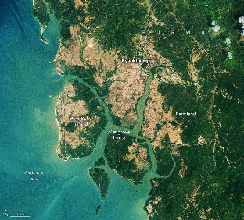
One of the sharpest turnarounds occurred in Southeast Asia, especially in Burma (Myanmar). The country experienced rapid mangrove clearing in the 1980s and 1990s as coastal areas were converted for agriculture and aquaculture and as wood was harvested for fuel. Around 2010, however, the trend began to shift, with mangrove area expanding in many locations. The researchers link this change to rising awareness and restoration activity following the catastrophic 2004 Indian Ocean tsunami, tighter legal protections for forests, and heavy sediment accumulation that created new mudflats suitable for mangrove establishment.
Satellite images from Palaw Township in Myanmar’s Myeik District illustrate the pattern: since 2010, mangroves have both returned to degraded areas and advanced into new ground. In parts of the region, regrowth appears to be taking hold in abandoned rice paddies south of the village of Kyauktaung. Nearby communities on Pyin Bukyi Island have also tried conservation initiatives and tree-planting projects to bolster mangroves.
Even with the recent gains, Myanmar’s longer-term losses remain stark. The country shed 28.6% of its mangroves between the 1980s and 2010. Since then, mangrove area there has increased by about 10%, the study reports.
Globally, the stakes are high. Mangroves are not tall—averaging around 13 meters—but they are powerful carbon reservoirs, with ecosystems that can hold up to four times as much carbon as inland tropical forests. They also blunt erosion and storm surges, while their distinctive root networks create nurseries for fish, shrimp, crabs and other marine species.
In some hotspots, nature has provided new territory. Near the Amazon River’s mouth and across northern Australia, abundant sediment deposition has formed mudflats that mangroves have colonized, contributing to steady regional increases dating back to the 1990s. At the cool edges of the biome, including the southeastern United States, warmer conditions and fewer hard freezes have enabled mangroves to extend into areas once limited by temperature, Zhang said.
Still, the recovery is uneven. In West and Central Africa, for example, losses in the Niger Delta have been large enough to pull the regional total downward since 2010. Other regions—including North America and southern Africa—have also suffered broad degradation after tropical cyclones tore through extensive coastal swaths.
Why it matters
Mangrove recovery can translate into stronger coastal protection, improved fisheries habitat and substantial climate benefits through carbon storage. The new satellite-based evidence suggests restoration and natural expansion are making a measurable difference, but also highlights regions where destruction and storm damage are still outpacing gains. What happens next will depend on enforcement of protections, sustained restoration, and how climate-driven extremes reshape coastlines.