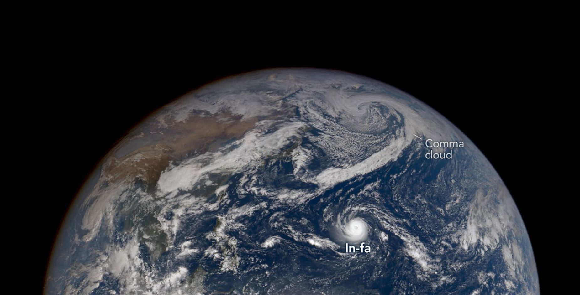
Super Typhoon In-fa developed an unusually large eye, and the remnants of Typhoon Champi transitioned into an extratropical storm that targeted Alaska.
Super Typhoon In-fa developed an unusually large eye, and the remnants of Typhoon Champi transitioned into an extratropical storm that targeted Alaska. Tropical cyclone activity in theNorthwest Pacific Basinhas been elevated since April 2026, whenSinlakusurged to super typhoon strength and battered Micronesia, Guam, and the Northern Mariana Islands. Twenty-five named storms later, the basin still hummed with activity in late October. When theEPIC(Earth Polychromatic Imaging Camera) on theDSCOVR(Deep Space Climate Observatory) satellite captured this image (above) on October 29, 2026, Super TyphoonIn-fachurned near the Mariana Islands. At the same time, the remnants of TyphoonChampiapproached Alaska amid aparade of stormsmoving across the Bering Sea. In-fa is thefifth typhoonto affect the Mariana Islands this year. TheMODIS(Moderate Resolution Imaging Spectroradiometer) on NASA'sTerrasatellite captured the image of In-fa below on October 30, when the storm was just west of the island chain. In-fa was unusually intense at the time of the image, with a nearly circular shape and large eye—a collection of characteristics that meteorologists use to identify a subset of tropical cyclones known asannular storms. These storms typically lack prominent outer spiral-shaped rainbands—a common feature of standard tropical cyclones—which is why meteorologists have a habit of calling annular storms"doughnuts"or"truck tires." Annular storms are rare, accounting for just 4 percent of tropical cyclones in the western North Pacific, according toone analysis. Their eyes average about 45 kilometers (30 miles) in diameter, compared to about 25 kilometers for standard tropical cyclones, and the storms typically maintain their strength longer in unfavorable conditions. In-fa was still atropical cyclonewhen EPIC captured the image at the top of the page, but Champi’s leftovers had gone through the process ofextratropical transitionand become a whole different type of storm as they entered the Bering Sea's busy storm track. Tropical cyclones arewarm-corestorms fueled by the heat and moisture of warm ocean water, butextratropical cyclonestypically havecold coresand draw energy from temperature contrasts between warm and cold air masses. Unlike tropical cyclones, extratropical cyclones typically develop fronts and huge, spiraling cloud bands shaped likecommas. "One of the calling cards of extratropical transitions is the expansion of a storm's wind field," said Gary Partyka, a meteorologist at NASA’s Goddard Space Flight Center. "It's not that the winds necessarily grow stronger, but they cover a much larger area," he said. In this case, there likely would still have been a midlatitude storm over the Bering Sea, possibly with large, comma-shaped clouds on October 30, even without Champi's remnants, he added. "But it looks like Champi became intertwined with and helped intensify that system," he said. Champi's transformation came after a long and destructive tour through the West Pacific, during which the typhoon achieved maximum sustained winds of nearly 300 kilometers (185 miles) per hour, prompting some observers to call it one of thestrongest stormsof the season. Despite narrowly skirting Taiwan and Guam, the powerhouse storm brought damaging winds and intense rains to both places, as well as to parts of China and Japan. When the remnants hit Alaska, the state avoided catastrophic damage on the scale of what happened after ex-typhoon HalongstruckinOctober 2025, but some areas did see high winds and heavy rain and snowfall, according tonews reports. Champi is the fourth ex-typhoon to enter Alaskan waters this year, noted University of Alaska Fairbanks meteorologist and climatologistRick Thoman, following Bang-Lang in August, Dujuan in September, and Choi-wan in early October. The autumns of 1997 and 2015—both very strong El Niño years—had three each, he added. Roughly 60 ex-typhoons have impacted the statesince 1970, according to Thoman. Partyka described 2026 as a "particularly active year" for Pacific tropical cyclones, increasing the chances that Alaska would be affected by storms that have gone through extratropical transitions. The strongEl Niño underwayin the Pacific is a "likely contributor" to the increased activity, he added. El Niñois a climate pattern that emerges roughly every two to seven years, marked by warmer-than-normal water temperatures in parts of the equatorial Pacific. In the Northwest Pacific, the phenomenon tends to cause storms to more readily curve northward rather than continuing westward to East Asia and Southeast Asia,some experts say, bringing more storms toward Guam, the Northern Mariana Islands, Japan, and the Korean Peninsula. NASA Earth Observatory images by Michala Garrison, using data fromDSCOVR EPICand MODIS data from NASAEOSDIS LANCEandGIBS/Worldview. Story by Adam Voiland. Stay up-to-date with the latest content from NASA as we explore the universe and discover more about our home planet. The third category 5 tropical cyclone of 2026 crossed the U.S. Northern Mariana Islands and Guam before continuing toward Asia. The Pacific was buzzing with storms while the Atlantic was notably quiet. The powerful storm delivered extreme rainfall and damaging winds to the state, passing the Island of Hawaiʻi as a category… Subscribe to the Earth Observatory and get the Earth in your inbox. NASA's Earth Observatory brings you the Earth, every day, with in-depth stories and stunning imagery. Open access to NASA’s archive of Earth science data